Friday, November 12, 2010

Sylvan Hills Subdivision


In April of 1922 J.R. Smith & M.S. Rankin published an article in the Atlanta Constitution about their new subdivision to be developed on 100 acres in south west Atlanta called Sylvan Hills. The property was located on what was then South Ashby Road, soon to be renamed Sylvan Road. The land was advertised to be nearly as level as a floor and situated in a forest of poplar, oak and hickory. The conveniences they associated with this new subdivision included: proximity to schools and churches, paved streets, paved sidewalks, water and sewer, two nearby trolley lines and its location within the city limits. The subdivision was to have few restrictions, however those restrictions included the following: "A 25 foot building line [setback] must be maintained; It is to be used exclusively for white people; [and] None of the properties can be used for stores or other commercial purposes." The property was subdivided into 50 x 150 ft lots and prices for these ranged from $775 to $1350.

By mid 1923 sales of lots and building of homes were well underway. Here is some of the wonderful verbiage associated with the promotion of Sylvan Hills Subdivision: "This splendid tract of gently rolling woodland is most appropriately named because over its entire extent the gracefully undulating knolls are covered with majestic forest trees, shading the hills and vales during the summer season, and furnishing much protection from winter blasts." Wow, trees as an asset, not an obstacle to be removed.

In May of 1924, H. A. Spencer of Norfolk, Virginia, announced the implementation of a "Cross-Town Bus" system that would run from Morningside to Sylvan Hills. The fare for riding the ten modern motor buses was 10 cents. Spencer is credited in the article as being the originator of the cross town bus system.

Home Beautiful Show Atlanta
Among the open houses for the 1925 Home Beautiful Show was a house located in Sylvan Hills on Melrose Drive (shown above). The house listed for $7,000 and was built by Wagar and Company.

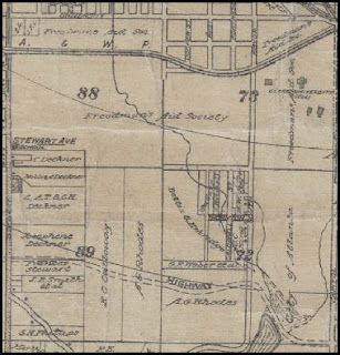
By July of 1925, 135 lots had been sold in Sylvan Hills. The subdivision was touted as: "one of the showplaces of the southside metropolitan section....just a comfortable distance from industrial centers." Its proximity to the city was also listed as an advantage, being reached easily via Sylvan Road, to Dill Avenue and then along Lee - all of which were paved roads, a huge amenity at the time. Road and infrastructure improvements were being made on Woodburne Drive, Harte Drive and Mickleberry Street to accommodate the demand for lots.

"The Sun Rises in Morningside and Sets in Sylvan Hills."
This hales from one of my favorite articles, primarily because I had gone searching to document the assertion that there were ties between Capitol View Manor and Morningside, and found instead much more to establish a tie between Sylvan Hills and Morningside. (Before anyone in CVM gets their knickers in twist, we do share a connection with both Morningside and Sylvan Hills in the form of real estate agents Maddox & Tisinger, who sold properties in all three neighborhoods, its just that we don't get mentioned like Sylvan does...often....and waxing poetically.) This particular article talks about James Jackson, a well known builder at the time. Jackson was building homes both in Morningside and in Sylvan Hills. Probably the most interesting part of this article is a discussion of the superior craftsman skills necessary to build a modern home using modern materials, and how that raises cost of construction.

Another builder who left his mark on Sylvan Hills is R.M. Cole. The promotional article for Cole published in 1925 talks about how his houses were the prettiest in Sylvan Hills. An interesting commonality that he shares with Mr. Jackson, above, is the emphasis on his expensive and highly skilled workman. Cole's homes were reckoned to be high class for the area and comment is made on the quality of housing as a whole within the subdivision, a standard which Mr. Cole sought to meet and exceed.

In 1926, Maddox & Tisinger become the real estate agents for Sylvan Hills. Paul Maddox anticipates that all lots will be sold soon, because people are "returning from Florida." (I thought that was pretty interesting and have earmarked it for further study....when I have a minute.) In addition, the development of new industrial sites was also driving the need for homes on the south west side.

By mid 1927, the Sylvan Hills Improvement Club has been established and was meeting on Deckner Avenue. One of the priority projects for the club that year was to secure land for a park to serve the residents of the growing Sylvan Hills subdivision. The property that was secured belonged to the Perkerson family and comprised 370 acres. At the time, only two buildings existed on the property that were deemed "of importance", the Perkerson home and a county school. The property was purchased and developed into a city park, with the contingency that the Perkerson home remain in ownership of the family during the remainder of their lives. City notables in favor of the project included: Mayor James L. Key, Alderman Charles M. Ford, Judge T.O. Hathcock, Frank Callaway, T.B. Hopkins, and T.H. Goodwin.

Monday, October 25, 2010

About Metropolitan Parkway/Stewart Avenue

Until 1997, the corridor that connects the neighborhoods of Adair Park, Pittsburgh, Capitol View, Capitol View Manor and Sylvan Hills on the southwest side of Atlanta and was once THE road south out of Atlanta was called Stewart Avenue. The road was named for Andrew Perry Stewart, who served for over twenty years as the (Fulton) County Tax Collector and was a resident of Capitol View.

Stewart was born in Jackson, Butts County, Georgia on December 14, 1848. His father, Frederick Stewart, served with 6th Georgia Artillery Battalion during the Civil War. A.P. Stewart came to Atlanta shortly after the close of the war, working first for Richardson's then for a hardware concern owned by L. B. Langford. Stewart purchased the hardware business on Whitehall Street upon Langford's retirement and ran that business until 1888, when he sold it to a Mr. Conklin. In 1889, Stewart ran and was elected as county tax collector, a position he held for many years. He was also active politically and served as a representative of the Fifth Ward. Stewart was also a Mason and an Oddfellow, and participated in a variety of civic activities.

Metropolitan Parkway/Stewart Avenue was also formerly: Vine Street, Humphries Street, Kreig Street, New Whitehall Road, and Ocmulgee. Stewart is part of the old Dixie Highway, which runs from Miami to Detroit. Per the Atlanta Constitution, the Dixie Highway was the brainchild of Clark Howell, editor of the paper.

In 1997, Stewart Avenue was renamed Metropolitan Parkway in honor of the college along its corridor. City Council cited that it would give the street, known for prostitutes, strip clubs and drug dealers a clean slate. We all know how well that worked out.

___________________________________________
Notes:
Men of Mark in Georgia, Vol. VI. William J. Northern, LLD, Editor, A.B. Caldwell, Publisher, Atlanta, GA, 1912. p.201-202

"Andrew P. Stewart." The Atlanta Constitution, November 27, 1910, ProQuest Historical Newspapers Atlanta Constitution (1868-1945). p. C8

"Andrew P. Stewart." The Atlanta Constitution, October 23, 1912, ProQuest Historical Newspapers Atlanta Constitution (1868-1945). p. C5

"Dixie Highway Trailblazers Visit Scenes of Effort 20 Years Ago." The Atlanta Constitution, February 21, 1936. ProQuest Historical Newspapers Atlanta Constitution (1868-1945). p. 11

"Many Streets Get New Names." The Atlanta Constitution, October 17, 1903, ProQuest Historical Newspapers Atlanta Constitution (1868-1945). p. 7

"New Name Gives Stewart Avenue a Clean Slate." The Atlanta Journal and Constitution, August 21, 1997. p. D2

Sunday, October 24, 2010

Capitol View War Housing

July 26, 1942, the realty firm of Haas & Dodd announced that they were selling houses for war workers on a 35 acre tract of land adjacent to Perkerson Park and near the Sylvan Hills subdivision. At this time, the new subdivision was called Fairmount Forest. The tract was located at the corner of Deckner and Stewart Avenue and was once part of the Perkerson properties. Fifty houses were planned for this subdivision and at the time of the announcement, twenty-four houses had been constructed. These were located on Belmont Avenue, south of Deckner and sold for less than $4,o00 for a five-room house and less than $5,000 for a six-room house.

Haas & Dodd noted that the houses were designed by "one of Atlanta's leading architects" to be in harmony with the existing houses in the community and that no two houses would look the same. The article cites that the subdivision and housing was authorized by the government for defense workers, which are described as: "a member of the armed forces, a person engaged in a plant producing war materials, either by direct contract or by subcontract, or an employee of a branch of the United States government engaged in war activity.

In a subsequent article in November of that year, the name of the subdivision had changed to Fairmount Park and we learn that the developer was Fairmount Development Company, though still being sold by Haas & Dodd. The 35 acre tract was subdivided into 125 lots. The lot sizes were considerably larger than those previously subdivided in Capitol view, the frontage being no less than 71 feet and the houses situated on the lots so that at least 25 feet stood between each house. The house set backs were determined by a desire to "preserve and balance the yard space."

By this time, the 50 houses had been completed, 32 of which had been sold, all to war workers. The completed houses were located on Belmont Avenue and Athens Avenue. The site was noted to be convenient to the Chevrolet Plant, Fort McPherson, the Candler Warehouse, the airport, and other war industry locations. The builder for this project was W. R. Jordan. The article repeated the previous assertion that the homes were designed by a leading Atlanta architect, unfortunately no name was ever mentioned.

NOTE: There is a picture associated with the 2nd article cited below, however AJC retains the rights to it and I can not publish on the page. However it is interesting in that the houses are very visible as there are no trees.
_____________________________________________
"To Build 50 Homes in New Subdivision for War Workers." The Atlanta Constitution, July 26, 1942, pg. 8D, ProQuest Historical Newspapers Atlanta Constitution (1868-1939).

"Fairmont Park Subdivision is Growing Fast." The Atlanta Constitution, November 8, 1942, pg. 7D, ProQuest Historical Newspapers Atlanta Constitution (1868-1939).

Sylvan Hills - 1911


Hi Sylvan Hills folks, didn't want to leave y'all out of the mix!

Here is the portion of the map that corresponds to most of Sylvan. I have been trying to find out more about why it is shown as Forrest Park, with no success yet. But maybe one of your neighbors know?


Also, thought you might like to see a closeup, (lower right). Looks like Southern Cotton Oil Co. had a location by the tracks. Will be digging up more info on them when I get a chance to.


__________________________________________
1911 Fulton County Map (portion of), produced by Hudgins Company, courtesy of the Georgia Archives


CVM - Erin Avenue

In 1944 Hillside Homes, Inc., began development of a War Housing Project on Erin Avenue in Capitol View Manor. The development was opposed by the existing residents of CVM, who cited sub-standard construction and a deleterious impact on their property values as cause.

Hillside Homes meanwhile was having additional trouble gaining support from the City, having lost a court battle to them over the provision of water and sewer infrastructure. An agreement was finally reached with the Fourth Ward Civic League, the City, and the neighborhood allowing construction on the contingency that Hillside Homes provide sidewalks and paving, and that the houses were differentiated by roof color and varying the front elevations of the proposed 35 homes.

Which houses are they? I have not confirmed this by documentation yet, however, this link may provide a clue:


______________________________________
"Greenlight is Expected for Erin Avenue Housing Project", The Atlanta Constitution, June 11, 1944, page 4B. ProQuest Historical Newspapers: Atlanta Constitution (1868-1945).

Friday, October 1, 2010

Capitol View Manor, Clark University and the Freedman's Aid Society


While researching a paper about the development of Stewart Avenue (Metropolitan Parkway), I discovered a 1911 Fulton County map in the Georgia Archives (map above, many, many thanks to the Georgia Archives for allowing me to post the image). The map showed that the bulk of the property on which Capitol View Manor sits was owned at that time by the Freedmans Aid Society (http://en.wikipedia.org/wiki/Freedmen's_Aid_Society). I was intrigued!

On the 1911 Fulton County map, Capitol View Manor is on land lot 88 (the yellow map is Land Lot 88 from the Fulton County GIS). The west edge is Stewart Avenue, our northern border is the Atlantic and Western Railroad. The wiggly line you see running through the northeast corner is a creek that originates in the Pittsburgh Neighborhood. Chances are good that the creek still exists in some form and neighbors on Hillside may see some evidence of it.

According to The Clark College Legacy by James P. Brawley, the money to purchase 450 acres of land (including the parcels on which the CVM neighborhood sits) was raised by Bishop Gilbert Haven. According to George Prentice in his book, The Life of Gilbert Haven: Bishop of the Methodist Episcopal Church, Haven was quite a radical, having been first an Abolitionist and upon coming to Atlanta, an agitator for the rights and dignity of the African American people. The land deal was brokered through Reverend Richard S. Rust of the Freedman's Aid Society in 1872 and purchased from a Mr. James M. Ball (from the Freedman's Aid Society Records 1872-1932, Roll 116, Entry from November 7, 1872, Atlanta University Center Archives). Per Brawley the land was purchased to support an agricultural program of the college. This program would: Supply food for the college, provide work for the students, train students to be agricultural workers, and serve the farming community of Georgia and the regional south. The program was extremely successful and Brawley reports that at the 1908 Annual Roundup Farmer's Institute, Perry C. Parks reported, "the growing of huge crops of vegetables, thousands of pounds of pork, thousands of gallons of milk and hundreds of pounds of butter."

In 1924 350 acres of land, including that on which Capitol View Manor sits, was sold to endow the college. The property was sold for circa $235,000. In September of 1926, Turman-Brown Realtors began selling lots in the new Capitol View Manor Subdivision.

____________
Notes:
1911 Fulton County Map, produced by Hudgins Company, courtesy of the Georgia Archives

Thursday, September 30, 2010

Things found behind a chimney in Capitol View

Clicking on a picture will enlarge it.


Stewart Avenue Substation


Info from Margaret Calhoun the archivist at Georgia Power:
This is the Stewart Avenue Substation built by a predecessor company of Georgia Power, the Georgia Railway and Power Company. In the early 1920s the power company had frequent interruptions of power so three small substations were built to strengthen direct current streetcar service in Atlanta. At least two of these, the Spring Street Substation and the Moreland Avenue Substation were designed by the electric company's corporate architect, Isaac. Moscowitz. The Stewart Avenue Substation uses many of the same elements as the other two. The drawings have not survived to determine for sure, but we assume that Moscowitz designed this, also.

I had inquired as to the possibility that J. Neel Reid had designed the building. They do not have that information, but if anyone knows anything about that, please let me know!

Ostrich Farm

According to Atlanta, yesterday, today and tomorrow, by John R. Hornady published 1922, there used to be an ostrich farm across the street from the Lakewood Fairgrounds. According to Hornady, this ostrich farm was the largest farm of its type east of the Rockies. Now, early city boosters are often given to hyperbole, however it would be interesting to know if anyone has heard something about this.

Tuesday, August 31, 2010

National Register Nomination

Capitol View Manor voted unanimously this weekend to have Richard Laub's MHP students prepare a National Register nomination. I hear tell that Capitol View voted unanimously for it as well. Congratulations both neighborhoods!

Monday, July 19, 2010

CVM's Emma Millican Park

The joint acquisition and development of "Millican Park" was announced by Dr. Charles Ross Adams, chairman of the finance committee of Fulton county on June 3, 1937. The 6 acre park would be the first in southwest Atlanta to provide recreational facilities for children. The parcel was to be purchased from the Deckner estate for $1500 and another $1500 was planned to establish four tennis courts, a baseball diamond, and playgrounds. The park was named in honor of Mrs. Emma Millican, mother of Senator G. Everett Millican of the 35th Georgia District. Senator Millican lived at 1029 Deckner Avenue SW and had in the past represented the 10th ward as an alderman.

Tuesday, April 6, 2010

Spring Forward Festival and History Display

I am energized by the response Amanda and I had to the history board and will be blogging my research into the neighborhoods and environment of Southwest Atlanta. More to come.